Brazil is a middle-income country, with vast biodiversity in ecosystems spanning from tropical forests to savannas. One of the more impoverished areas in Brazil is in the Northeast, where the semi-arid region is geographically concentrated, occupying almost 1 million ha. The Brazilian semi-arid region is the most populated and the rainiest in the world. The focal study area for XPaths in Brazil is the São Francisco River Hydrographic Region, 54% of which is in the Brazilian semi-arid region. The São Francisco River Hydrographic Region is 2,800 km long, covering six Federative States states - plus the Federal District - 505 municipalities, and it corresponds to approximately 8% of the Brazilian territory (CBHSF, n.d.).
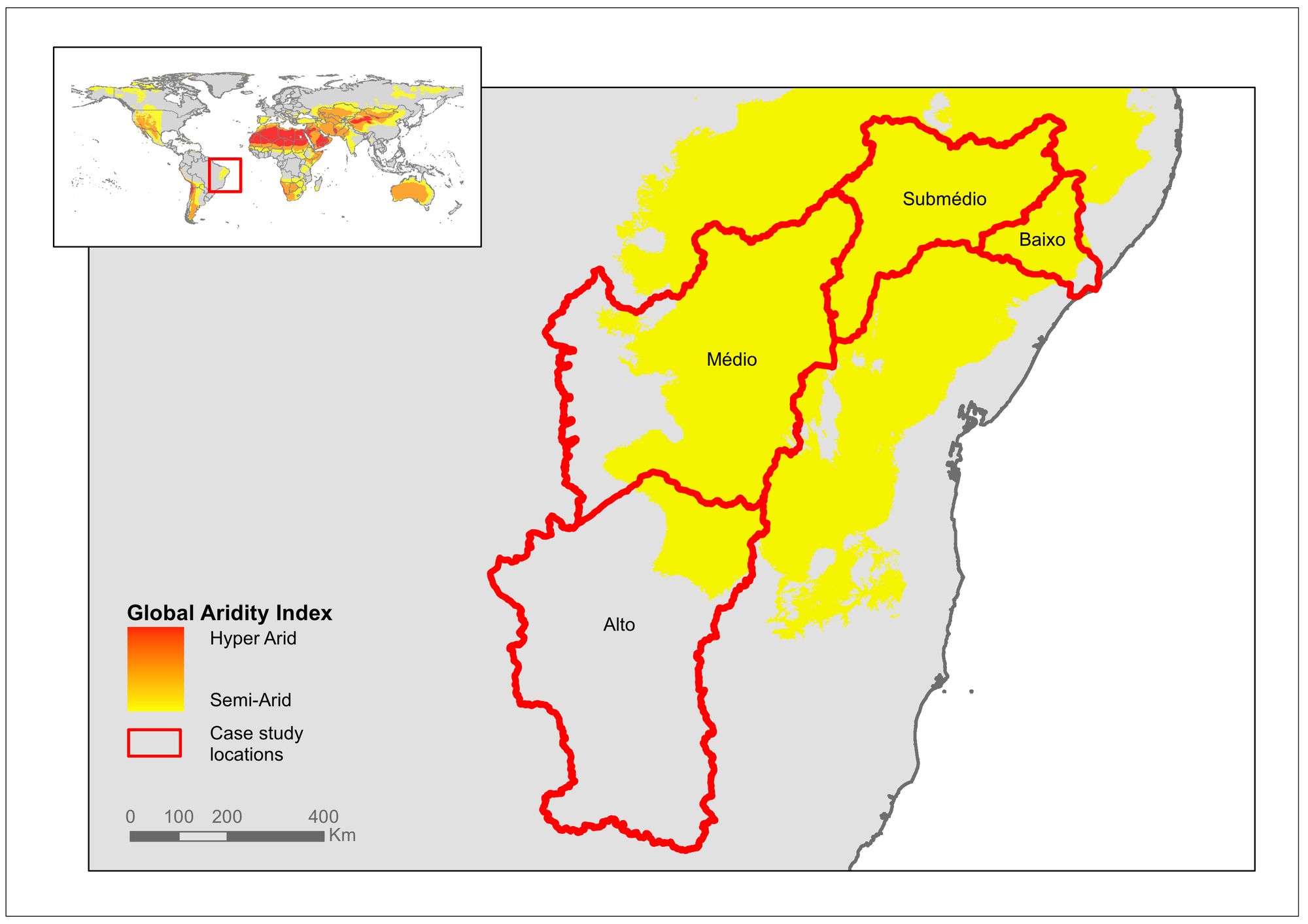
The São Francisco River has 168 tributaries - freshwater streams that are connected to and feed into a larger parent river, rather than directly to the ocean. However, more than 40% of the freshwater streams are intermittent, disappearing during the dry season. The river is of extreme importance for the country and region, ecologically, culturally, and economically - due to its role in providing water, food, and energy. The São Francisco river basin covers a vast area and large contrasts between regions, between states, between urban and rural areas, and also between population groups. It reproduces, to a large extent, the inequality that still characterizes Brazilian society. Due to its diversity and for planning purposes, the basin is divided into four physiographic zones or regions: Upper (Alto), Middle (Médio), Sub-Middle (Sub-Médio), and Lower (Baixo) São Francisco regions, as the map illustrates.
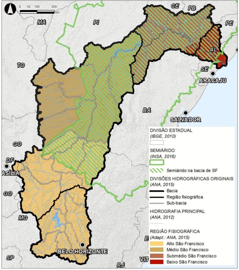
There is a stronger presence of industries and agro-industries in the Upper, Middle, and Sub-Middle regions. The agro-industry has its industrial grain and fruit growing centers located in the North and West regions of Bahia, and the south of Pernambuco. The West part of the Bahia State is superimposed by the area known as MATOPIBA - the most important area in the country of large-scale grains agriculture for export, and which depends heavily on modern irrigation systems. The modern irrigated fruticulture pole in Petrolina/Juazeiro, produces grapes, wine, and mango for internal and external markets. However, even in these regions, while some municipalities are characterized by a high level of agricultural production and comparatively better social indicators, large inequalities and a high level of conflict affect the majority of the municipalities with persisting structural social problems and traditional agro-pastoral systems (Bouckaert et al., 2020).
At the same time, the constant droughts recurrently cause an emergency concerning water supply for human consumption, worsened by the high demand for irrigation systems. As a result, the main challenge and conflicts of the basin are related to water access and demand, as around 70% of the basin's water demands are for irrigation (ANA, 2020), with greater concentration in the Middle and Sub-Middle. As a consequence, the Lower region, where the riverside socio-economy is still strongly linked to traditional agriculture and fishing methods, suffers the most from the decreasing amount of water in the river.
Another challenge in the region is desertification. The environmental and climatic characteristics of the Brazilian semi-arid, associated with the over-exploitation of natural resources (mainly by agriculture and livestock) and limiting socioeconomic aspects over the years, have triggered the degradation/desertification process in several parts of the region. Finally, according to recent climate scenarios, the Northeast of Brazil will be severely affected by climate change.
In sum, we will in XPaths investigate how the SDGs could be reached, and what they mean, in such a complex situation. In Brazil, we will work in close scientific collaboration with another project with similar goals, the NEXUS project, led by the Brazilian Institute of Space Research.
References
Agência Nacional de Águas e Saneamento Básico (ANA). (2020). Conjuntura dos recursos hídricos no Brasil 2020: informe anual / Agência Nacional de Águas e Saneamento Básico. Brasília: ANA.
Bouckaert, F. W., Vasconcelos, V. V., Wei, Y., Empinotti, V. L., Daniell, K. A., & Pittock, J. (2020). A diagnostic framework to assess the governance of the São Francisco River Basin Committee, Brazil. World Water Policy, 6(1), 8-37. https://doi.org/10.1002/wwp2.12022
CBHSF - Comitê da Bacia Hidrográfica do Rio São Francisco. (n.d.) Accessed in 05/10/2021 https://cbhsaofrancisco.org.br/a-bacia/#regioes-hidrograficas
NEMUS (2016). Plano de Recursos Hídricos da Bacia Hidrográfica do Rio São Francisco 2016-2025. Associação Executiva de Apoio à Gestão das Bacias Hidrográficas Peixe Vivo. Comitê da Bacia Hidrográfica do Rio São Francisco. http://nexus.ccst.inpe.br/
Comments